|
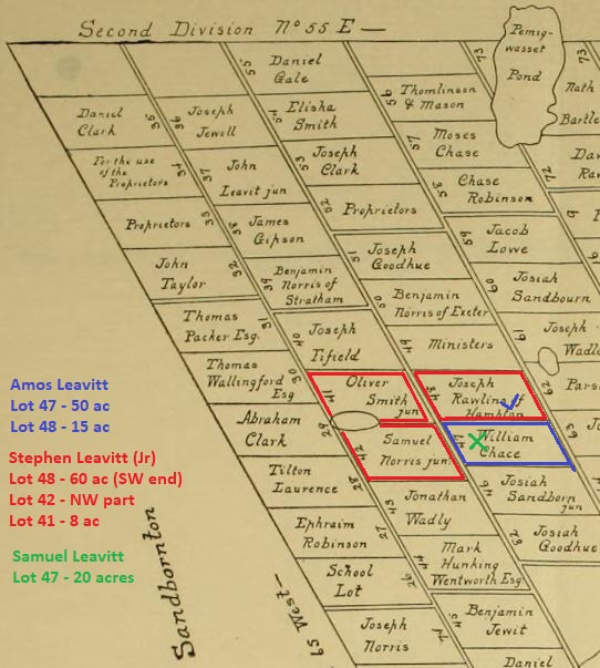
While John Leavitt was the first of that surname to own land in Meredith [see: The Proprietors of Meredith], it wasn't until much later when a Leavitt family actually moved into town to settle. No Leavitt was found as a Revolutionary War soldier serving from Meredith. Prior to this, a check of the 1776 Association Test for Meredith lists the names of 48 men [NHSP, Vol. 30, pg 93], though none had the Leavitt surname. Joseph "Roberds" (Roberts) was on this list, having moved there with his wife Eunice (Leavitt) [Desc. of Nehemiah v.6, pg 15/21] some time after 1771 [Joseph purchased, from his widowed mother Abigail Roberts, the original rights in Meredith of Oliver Smith on 18 Mar 1766. He was still in Brentwood at this time - Strafford County Deeds, Bk. 2, pg 415]. By the time of the 1790 census for "Merideth", (then in) Strafford County, the following six Leavitt names are now found in town: Amos , Levi , Nehemiah, Samuel, Stephen, and Weare Leavitt. This blog entry will focus on these early settlers. AMOS LEAVITT (1759 - 1843) On 18 April 1787, Amos Leavitt "late of Raymond but now of Meredith" purchased 50 acres from east end of lot #47 in the 2nd Division, from Jonathan Dow [Strafford County Deeds, Bk. 20, pg. 25]. He purchased another 20 acres that bordered him, in 1793, and a 15 acre piece out of Lot 48, 2nd Div., from Stephen Leavitt [Strafford Deeds, Bk. 20, pg. 26 and Bk. 50, pg. 128]. He sold all of this to James Glines in August 1805, himself buying the said Glines property in New Hampton [Bk. 50, pg. 129]. Amos would later return to Meredith, where he died in 1843. He was a Revolutionary War veteran. - Descendants of Nehemiah Leavitt, v.6, pg 18/19 LEVI LEAVITT (1761 - 1840) A 1797 delinquent tax list for Meredith shows a Levi Leavitt living on the "S. Lane" farm, which was located in the 2nd Division, Lot 8 (115 acres). He and wife Sarah (Pearson) of Meredith, sold property (in her right) of Joseph Parsons (or Pearson) of Meredith in 1799 [Strafford Cty Deed, Bk. 30, pg. 283]. The census numbers (2 males under 16, 1 male 16+, and 2 females) match that of the Levi found in the Desc. of Samuel Leavitt, pg 94-95. He later moved to Vermont. NEHEMIAH LEAVITT (ca 1752 - 1829) With 3 males under 16 yrs of age in the 1790 census, this would likely be the Nehemiah from the Desc. of Nehemiah Leavitt book, pg 25-27. He married Sarah Philbrick in Chichester, NH, 1777, and moved then to Gilmanton, serving several times during the Rev. War. A 1781 deed [Straff. Cty, Bk. 4, pg 29] shows him selling property in Gilmanton, so perhaps moved to Meredith following this. No deed found with him purchasing land in Meredith prior to this census. SAMUEL LEAVITT (1770 - 1852) Descendants of Nehemiah Leavitt, v.6, pg 27/43. In Meredith by 1789, when he married Mary Smith, and purchased land on 24 Sept 1790 [Strafford Cty Deed, Bk. 19, pg. 282]. The 20-acre tract was part of Lot #47 in 2nd Division, and bordered that of Amos Leavitt (see above), his uncle. He sold part of his homestead farm in 1793, the bounds mentioned being on "southwest side of highway from Amos Leavitt's home to Sanbornton line". STEPHEN LEAVITT (abt 1745 - after 1800) "Moved from Poplin (Fremont) to Meredith when son Samuel [see above] was a boy" - written in a letter from W. B. Leavitt to JPL , 28 Dec 1877 [quoted in Desc. of Nehemiah Leavitt book, pg. 27/45-46]. Land deeds prior to 1800 not seen. Relatives say he went to the British Dominion, or went east, while family remained in Meredith. Wife Mary (Roberts) lived to age 102. WEARE LEAVITT (1742 - 1829) Descendants of Moses Leavitt, pg 63. Living at Meredith Neck by June 1788, when he signed a petition to incorporate a new town from the eastern portion of Meredith, and north through New Hampton (to be called Watertown) - it was rejected [NH State Papers, Vol. XI, pg. 277]. No deed was found (so either a town grant or through a relative's probate), but he had at least 50 acres in Lot #42, in 3rd Division on the Neck, as he sold off tracts from it in 1805-06. Below is a part of the 1770 map of Meredith, New Hampshire, with the lots in the Second Division marked out with the Leavitt owners. They didn't own the complete 120-acre lots, and the land deed descriptions are vague at times, making it difficult to properly determine their exact bounds. Note: some of these deeds took place after the 1790 census, so are not mentioned above. Randlett Pond (GPS: 43.579067, -71.568975) can be seen drawn on the border between Lots 41 and 42.
0 Comments
Leave a Reply. |
NALF NotesUpdates about our Leavitt genealogy research, our DNA projects, and other notes to keep our membership informed. Archives
September 2023
Categories
All
|

 RSS Feed