|
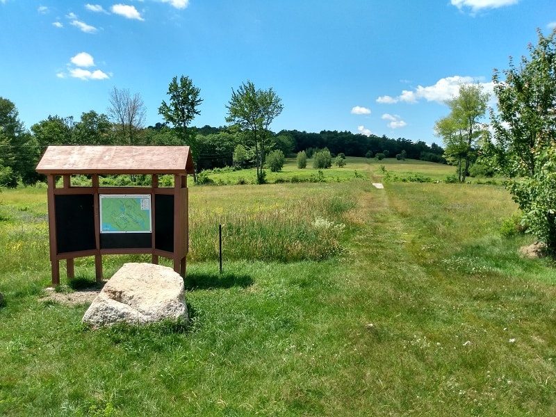
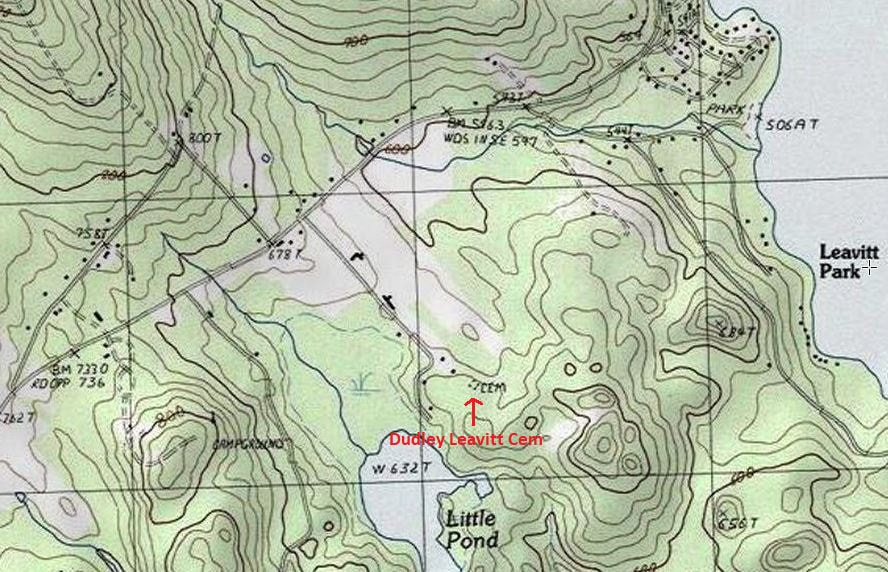
Following the NALF Reunion at Hart's Turkey Farm Restaurant, on 25 June 2022, and a visit to the Historical Society Museum downtown, it was time for a hike. The Page Pond Community Forest in Meredith has several parking lots, and I chose the southern entry point, on Barnard Ridge Road. 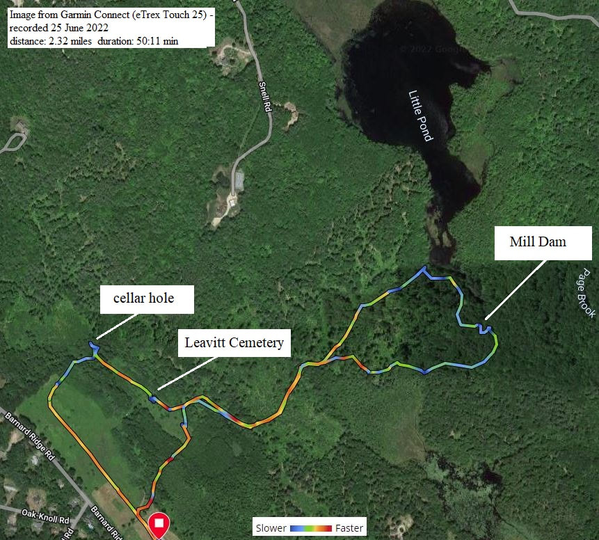
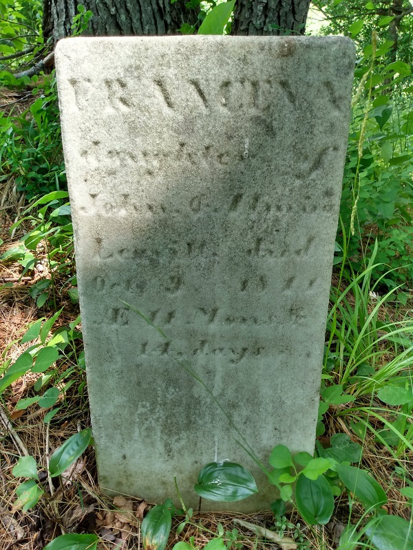
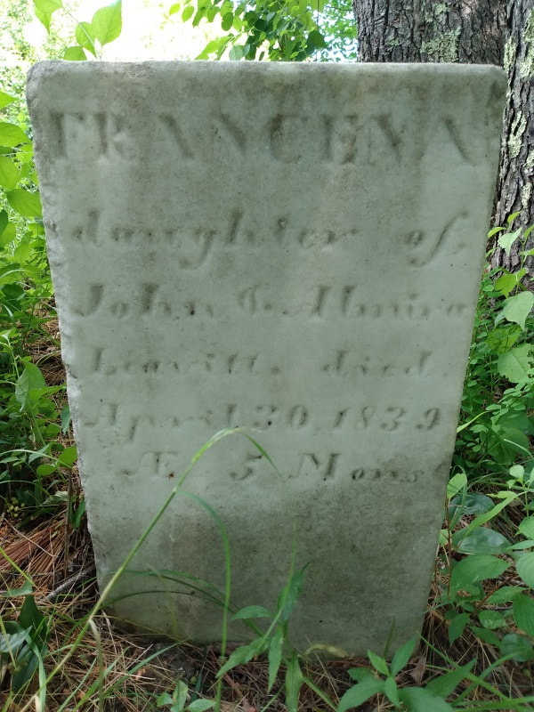
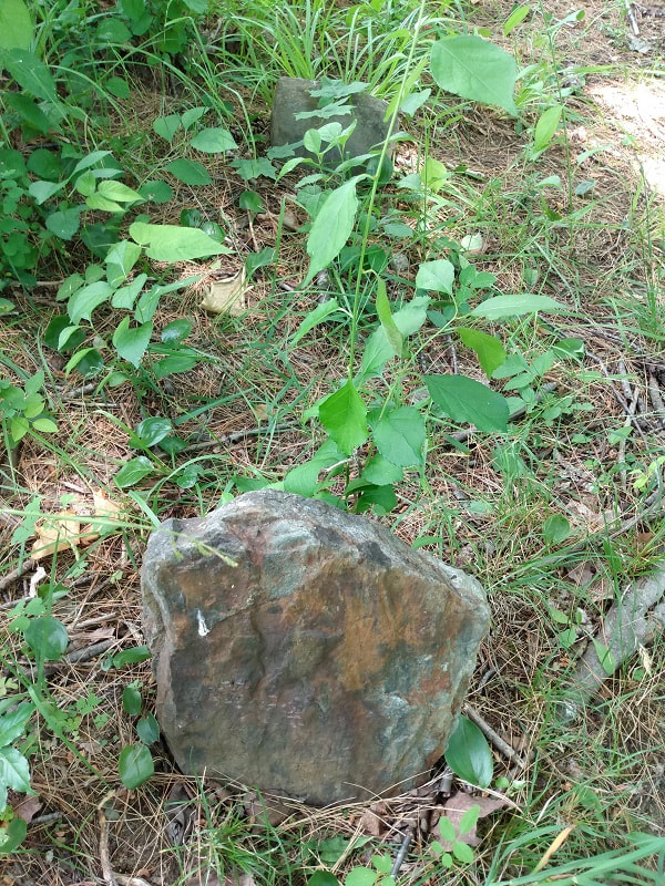
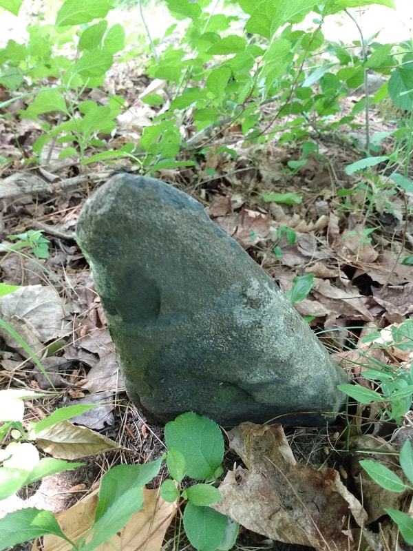
Next is the LEAVITT Cemetery. 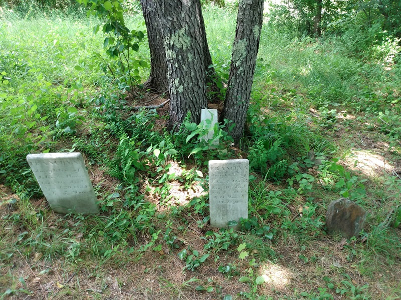 There are only two stones here with inscriptions: Francena, daughter of John & Almira Leavitt, died 30 April, 1839, AE 5 mos Francena, daughter of John & Almira Leavitt, died 9 Oct 1841, AE 11 mos & 14 days John Leavitt was the son of Joseph, a son of the Weare Sr. who lived on this land. Weare Sr., who died in 1829, and wife Betsey (d. 1818), may lay here. When Weare Jr. sold his deceased father's half of this lot in 1830 [Strafford County Deeds: Vol. 149, pg 142], the deed mentions "excepting the burying ground, thirty feet square".
There is another burial directly beside them, marked with field stones, whose size suggests another young child. A few feet away are a couple of other field stones, their positioning seemingly showing perhaps two other burials.
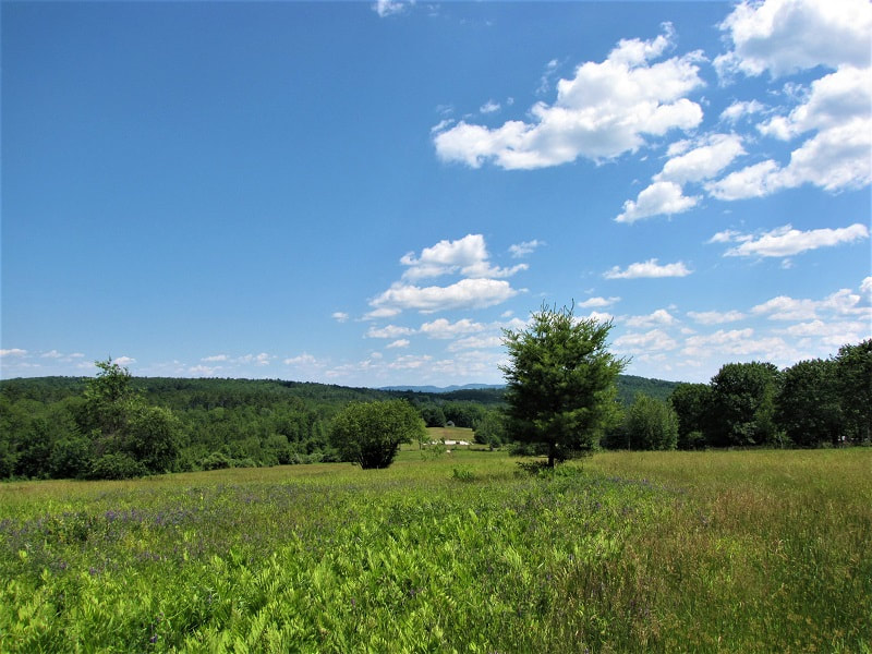
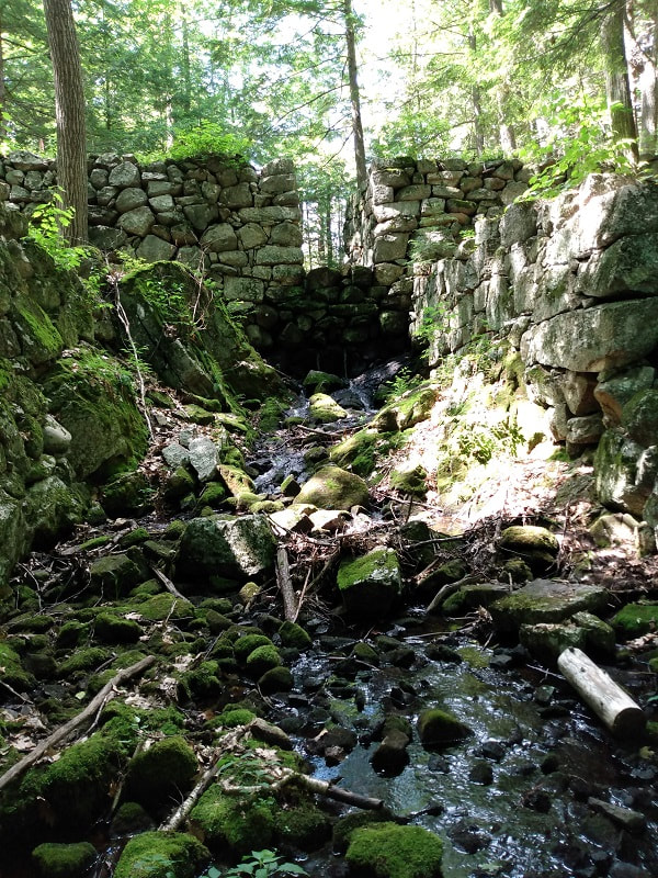
On the way to the mill dam, there is a fine view of Page (aka Little) Pond. 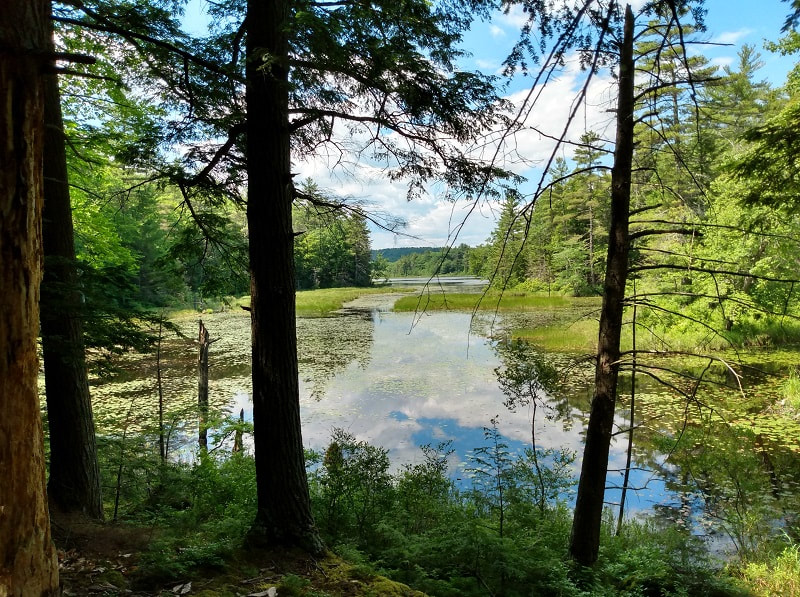 Sewall (or Sewell) Leavitt was another son of Joseph Leavitt. He purchased, from James Gilman, a lot below Little Pond in May 1830, and built a saw mill and dam on the brook. He bought another piece from Gilman adjacent to this in 1835. Only a year later, on 25 Nov 1836, he sold it all to John Page [Strafford County Deeds: Vol. 172, pg 61], and would relocate to Manchester, NH.
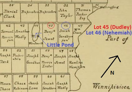
Lastly, using part of a map from "NH Stone Wall Mapper", some of the old lot lines, or parts of them, can still be seen (in purple). I've roughly outlined the bounds of Lot #42, 3rd Division, and circled the Leavitt cemetery on the knoll, and the mill dam locations. 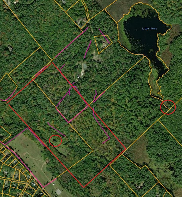
0 Comments
From the 1892 map of Meredith, New Hampshire, published by D. H. Hurd & Co. of Boston, MA. Full map available on the David Rumsey Map Collection website. 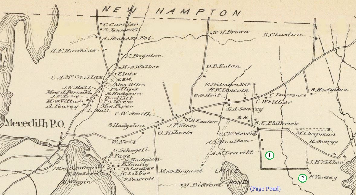 1. "A. E. Leavitt" Arthur Eastman Leavitt (1831-1911), grandson of Dudley Leavitt (1772-1851), who lived on the former property of the almanac maker. - Desc. of Moses Leavitt v1 pg 97/120 2. "R. Veazey" Home of Rufus L. Veasey. He purchased this property from Arthur E. Leavitt on 29 Aug 1866, two months after Arthur acquired the land from the heirs of John D. Leavitt. John was the son of Nehemiah Jr (1787-1850), and grandson of Nehemiah Sr (abt 1752-1829). Arthur and John were 5th cousins. 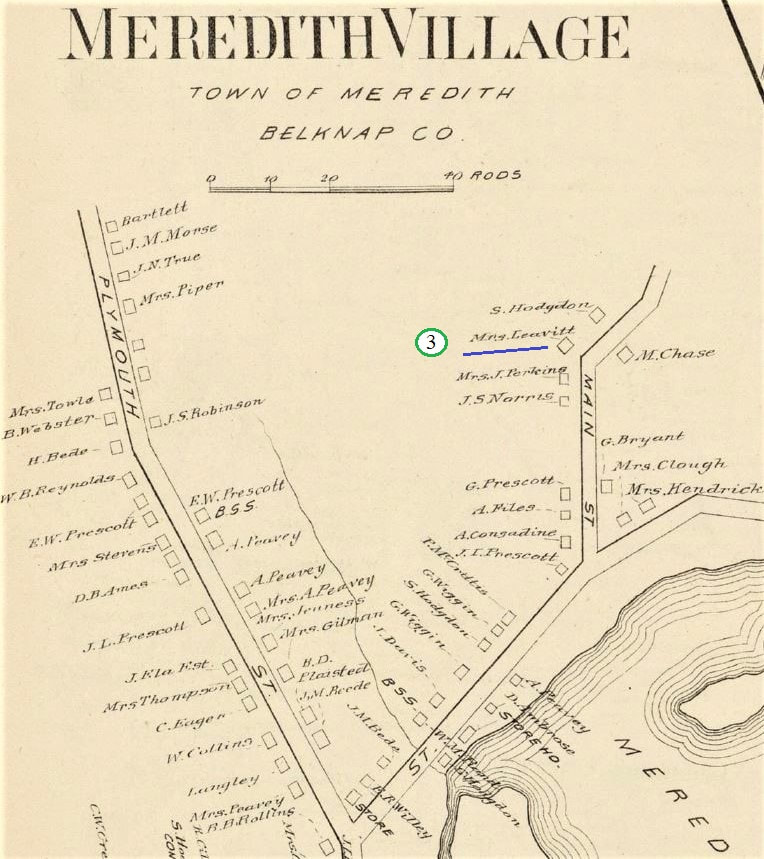 3. "Mrs. Leavitt" Olive (Bartlett) Leavitt was the widow of Daniel (1817-1858), son of Nehemiah Jr (1787-1850). Of her five children, only Nancy survived to adulthood. Olive was living in Laconia by 1895, presumably with her daughter, but still held on to her village property. - Descendants of Nehemiah Leavitt v6, pg 55 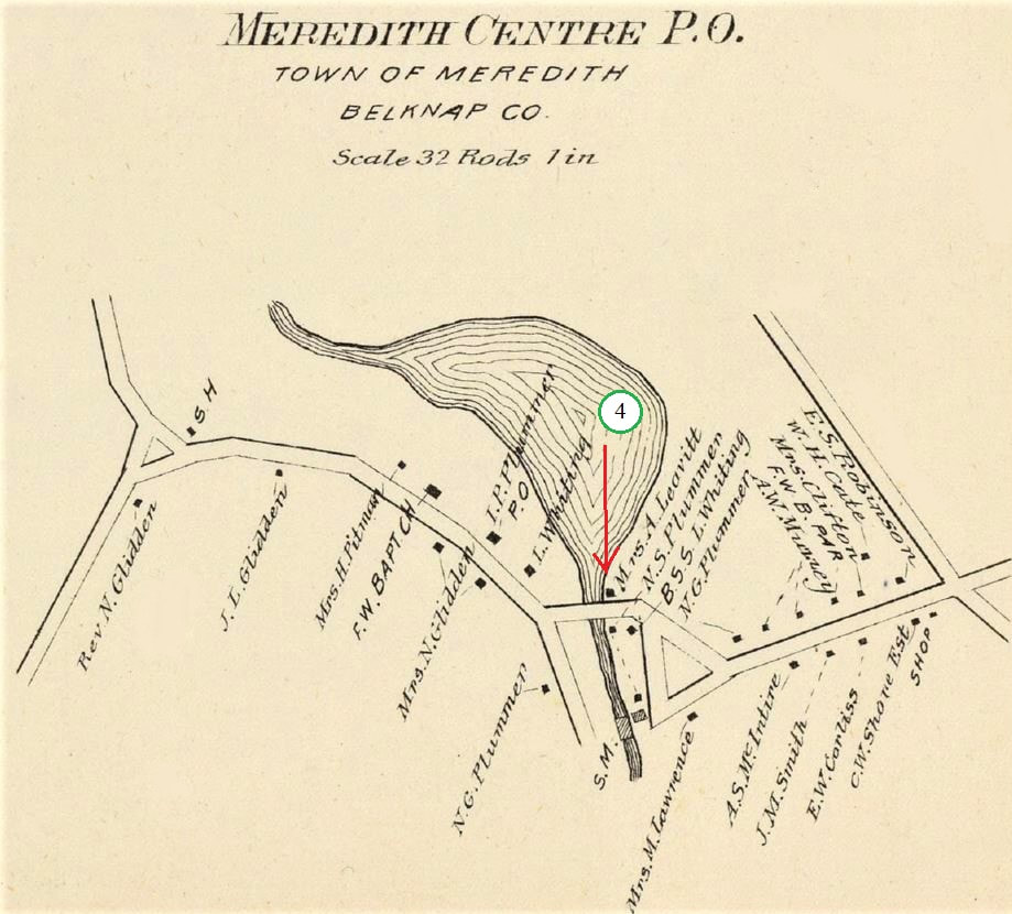 4. "Mrs. A. Leavitt" Currently unknown who this person was. In 1880 and 1900 Meredith censuses, there are no women with an "A" first name. If she was using her husband's name, there is only a match with Arthur, and his wife Elizabeth was with him in both censuses. It has yet to be researched if an "A' named Leavitt owned property here, but hadn't lived in town. A "D. Philbrick" is on this spot in the 1860 Meredith map. 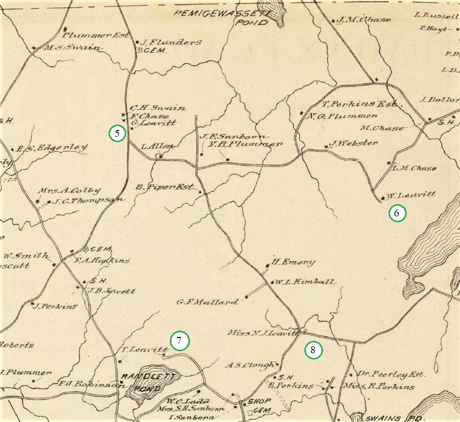 5. "G. Leavitt"
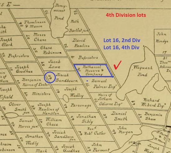
George Smith Leavitt (1840-1905), son of Joseph and Julia A (Smith) Leavitt. He moved to New Hampton after 1892, and died in Laconia. He was buried in New Hampton. [Desc. of Nehemiah v6, pg 69] 6. "W. Leavitt" Warren B. Leavitt (1834-1909), the son of Bradstreet [Desc. of Nehemiah v6, pg 52]. Warren is buried in Oakland Cem, Meredith Center, though father and grandfather Samuel are both found in the family plot on this farm. 7. "T. Leavitt" Thomas L. Leavitt (1828-1902), son of John and Sarah (Edgerly) Leavitt. He and sister Mary (both single) had moved to Gilford, later to Lakeport (Laconia), but still had the old homestead in Meredith. Their parents are buried there, off of Leavitt Mountain Road. - Nehemiah line 8. "Miss N. J. Leavitt" Nancy Jane Leavitt, daughter of Thomas and Sarah Jane (Randlett) Leavitt, never married, and lived with her parents. Being the only heir when they passed in the 1880's, she inherited the farm. [Desc. of Nehemiah v6, pg 83] 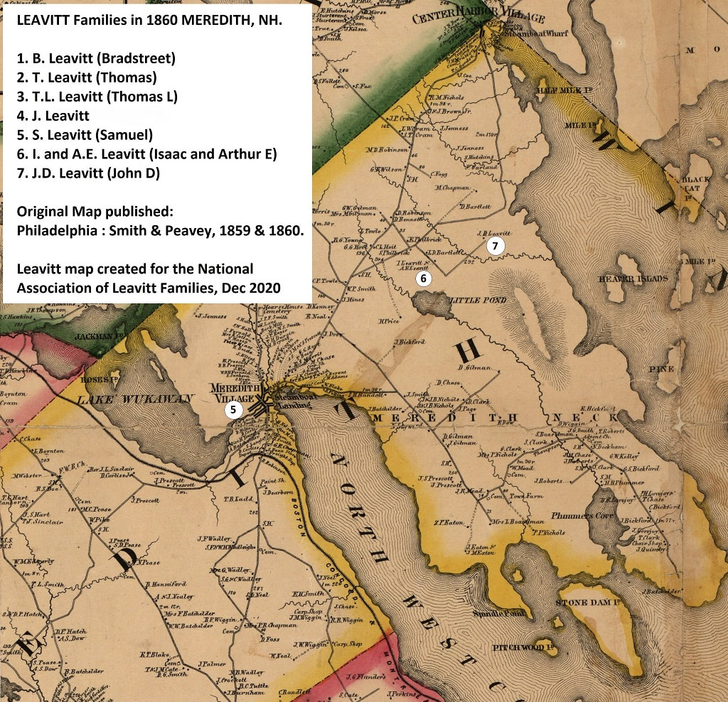 CLICK on image to enlarge Above is a clipping of the town of Meredith, from a Belknap County, N.H. map, drawn by E.M. Woodford, and published by Smith & Peavey in 1859 and 1860 (the full map can be found on the Library of Congress website). There were seven Leavitt households found on it - these families can be identified by comparing their names with the census of 1860. PART II will focus on the eastern side of town [Part I here]: 5. "S. Leavitt" - Samuel Leavitt (1800-1869) lived in Meredith Village, on High street. While both the 1850 and 1860 censuses show him as a carpenter, the Desc. of Nehemiah book (pg 78) called him a Free Will Baptist minister. 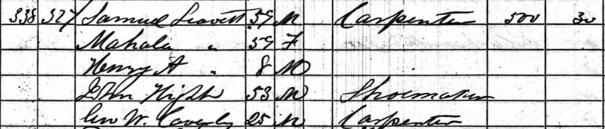 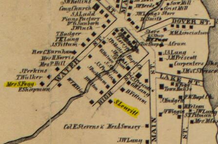 Not marked on the map, but seen as owning land in the 1860 census, is George A. Leavitt. He was the son of Emerson Leavitt [Desc. of Nehemiah, pg 32/33], and lived on Water Street. On the above map, the home of "Mrs. S. Fogg" is highlighted. She is Susannah G. Fogg, who George and his family were living with at the time. 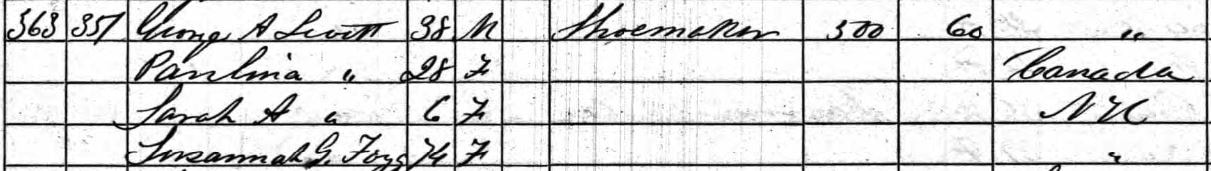 6. "I. & A. E. Leavitt" - Isaac Leavitt (1798-1881), son of the well-known Dudley Leavitt, and his son Arthur E. (1831-1911), lived on Lot 45 in the 3rd Division, land purchased by Dudley after moving to Meredith from Gilmanton [Strafford County Deeds, 66-222; 97-162]. They are from the "Moses line", found in the Desc. of Moses Leavitt genealogy, on pg 97/120. 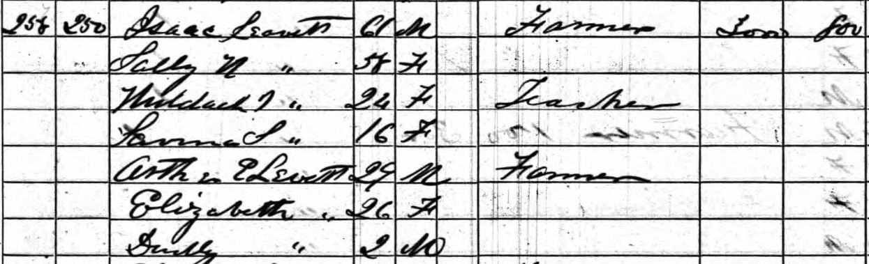 7. "J. D. Leavitt" - John D. Leavitt (1827-1866) was the son of Nehemiah [Desc. of Nehemiah Leavitt, pg 41. The 1860 census shows him being in the household of Ebenezer Sturtevant, though John was the owner of the land.  Having been severely injured in the town hall collapse back in 1855, John led a pain filled life, until his death in 1866. His land, formerly that of his father, was sold by his heirs [Belknap Deeds, 44-155] to their (distant) cousin next door, Arthur E Leavitt (see #6). The 150 acres included Lot 48, which bordered on Lake Winnipesaukee. Below shows the 1770 map of Meredith, showing where lots 45 and 46 were in the Third Division, northeast of "Little Pond". A map from the 1980's has the Dudley Leavitt cemetery marked out, just north of the pond.
Another person not found on the 1860 map is Dorothy J. Leavitt, widow of Samuel T. Leavitt [Desc. of Nehemiah, pg 44]. At the time of the enumeration, she was living in the household of Daniel Hilton and his family. He lived on Main Street, opposite Cross St., on the 1860 Village map [see Library of Congress map].
 CLICK on photo to enlarge Above is a clipping of the town of Meredith, from a Belknap County, N.H. map, drawn by E.M. Woodford, and published by Smith & Peavey in 1859 and 1860 (the full map can be found on the Library of Congress website). There were seven Leavitt households found on it - these families can be identified by comparing their names with the census of 1860. PART I will focus on the western side of town: 1. "B. Leavitt" - This is Bradstreet Leavitt, son of Samuel [Desc. of Nehemiah, pg 52]. Also written as "Broadstreet" in early papers, he purchased half of his father's holdings in Lot 16, 2nd Div., in 1837, including land in Lot 16, 4th Div., which bordered it [Strafford Deeds, v. 180, pg 459]. He purchased another 39 acres from adjoining lot 60 in 1839, from David G. Smith [Straff Deeds, v. 180, pg 435]. He died in 1883, and was buried in the family cemetery on the property, along with his wife, parents, et al [See LEAVITT Cem on Find a Grave]. 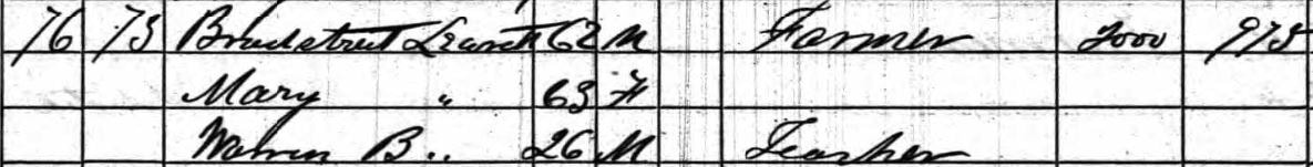 1860 Meredith, NH census, pg 8
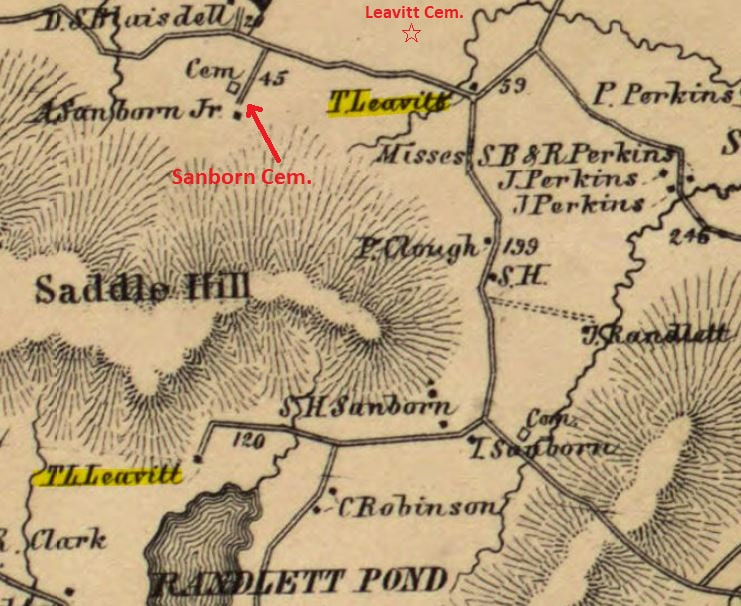
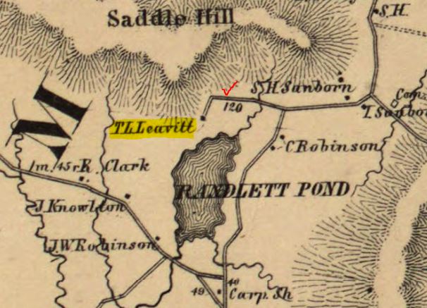
2. "T. Leavitt" - Thomas Leavitt (1794-1880) A descendant of Nehemiah [Vol. VI, pg 83], he lived on the north side of "Saddle Hill", which would be renamed Leavitt Mountain. He owned land in Lot 63, 2nd Division. He first purchased 1/2 of the 120 acre lot from his father John in 1817 [Straff. Deeds v.116, pg 435], and another 30 in 1828 [v.151, pg 462]. His brother Ebenezer had property in Lots 60 and 61, which their father had sold him in 1832. 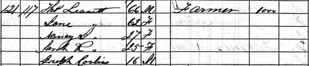 1860 census, pg 13
He is buried, along with his wife Jane (Randlett) and their three unmarried children, on the old homestead. Daughter Nancy J. was the last to live on the property, her will, dated 1888 (proved in 1902), left 100 acres (in two lots) to Warren L. Glidden, provided he live on the farm and "take care of the farm in a husband like manner" and care for her "in sickness and health" [Belknap County Probate, Vol. 26, pg 512]. His parents, John and Sally (Ward) Leavitt, are buried nearby in the Sanborn Cem. (Asahel Sanborn purchased the westerly end of the "burying yard" from Ebenezer K. Leavitt in 1851). 3. "T.L. Leavitt" - on the south side of "Saddle Hill" was Thomas L. Leavitt (1828-1902) another member of the Nehemiah line [Vol. VI, pg 65], the son of John and Sarah (Edgerly). His father had purchased Lot 42, 2nd Div., in 1818 [Straff. Deeds, v. 6, pg 228], later selling it to Thomas' eldest brother Levi in 1844. Levi would, in turn, "sell" it back to his parents in 1852, for use during their natural lives. Following their father's death in 1855, Levi sold the lot to Thomas [Belknap Deeds, v. 27 pg 525]. 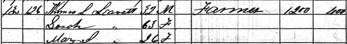 1860 census, pg 14 Thomas and his sister, Mary J., didn't marry, and shared the household. Sarah, his widowed mother, was with them in the 1860 census. The siblings are both buried in Laconia's Union Cemetery [see our cemetery page for Laconia], sharing a plot with their Uncle Ebenezer K. Leavitt.
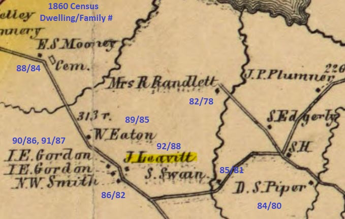
4. "J. Leavitt" - Likely the home of Joseph Leavitt (1807-1858) Though deceased at the time of the 1860 census, his widow Julia was still living there with two children. Her father, Levi Smith, had sold the property to her husband in 1841 [Belknap Deeds v.2, pg 41], which was all he then owned in town. The deed included the stipulation that Joseph and Julia cared for her parents and let them stay in the household, along with their other children.
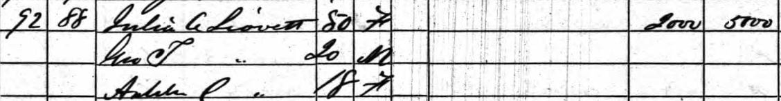 Julia's brother, Noah W. Smith, seen on the opposite of the road on the map, had earlier purchased 1/2 of his father's estate. Both Joseph and Julia (who died in 1864) and their dau. Addie C. were buried in the Smith Cem, but their son George S. Leavitt (in his 1905 will) asked that they be re-interred in his New Hampton Village Cem. lot. This may not have happened, as his stone [Find a Grave] has all of their names inscribed, with "buried in Smith Cemetery, Meredith" at bottom. The entry for the Smith Cemetery on Find a Grave doesn't list any Leavitts, and no disinterment forms were filed in NH VR. Joseph Leavitt, son of Samuel, is found in the Desc. of Nehemiah VI, pg 68-69. ------- Found in the 1860 census living in Meredith, but NOT marked on the 1859/60 map of Meredith, was the family of Jeremiah W. Leavitt. He spent most of his life in New Hampton, but had apparently briefly crossed over the border just in time for the census. Looking at his household, there is a "Ruth Ranlet", aged 55, listed with him. 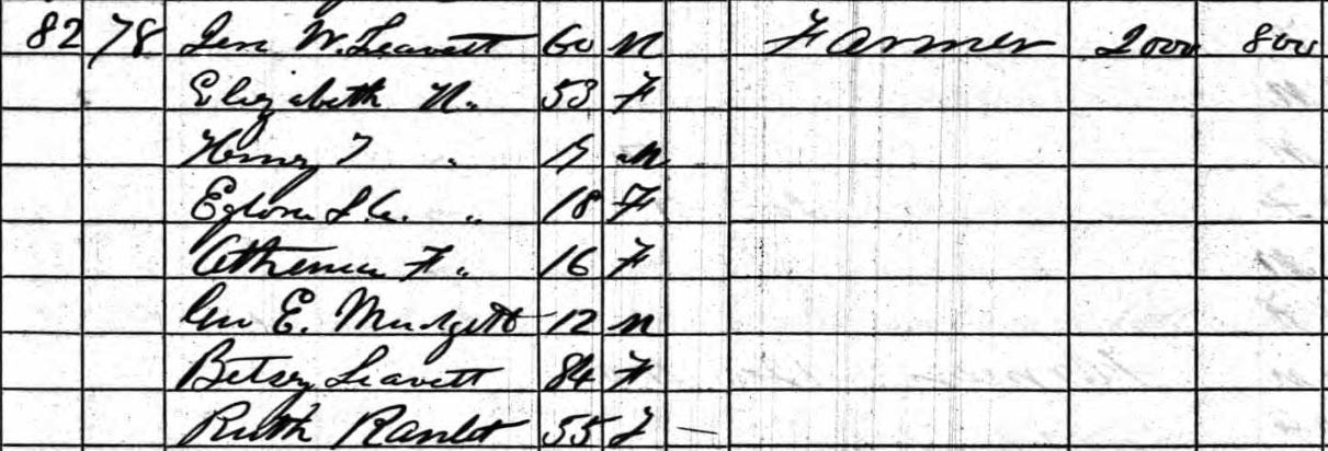 1860 census, pg 9 On the 1859/60 map, marked just north of the J. Leavitt homestead (see #4 above), is a "Mrs. R. Randlett". The order of enumeration would place him in this vicinity. The home probably belonged to Ruth, as other censuses find her around this location, so the estate value should have been listed beside her and not Jeremiah. Jeremiah Leavitt is found in the Desc. of Nehemiah VI book, on pg 35/63. ------- MEREDITH, NEW HAMPSHIRE in 1860 - continued in PART II
While John Leavitt was the first of that surname to own land in Meredith [see: The Proprietors of Meredith], it wasn't until much later when a Leavitt family actually moved into town to settle. No Leavitt was found as a Revolutionary War soldier serving from Meredith. Prior to this, a check of the 1776 Association Test for Meredith lists the names of 48 men [NHSP, Vol. 30, pg 93], though none had the Leavitt surname. Joseph "Roberds" (Roberts) was on this list, having moved there with his wife Eunice (Leavitt) [Desc. of Nehemiah v.6, pg 15/21] some time after 1771 [Joseph purchased, from his widowed mother Abigail Roberts, the original rights in Meredith of Oliver Smith on 18 Mar 1766. He was still in Brentwood at this time - Strafford County Deeds, Bk. 2, pg 415]. By the time of the 1790 census for "Merideth", (then in) Strafford County, the following six Leavitt names are now found in town: Amos , Levi , Nehemiah, Samuel, Stephen, and Weare Leavitt. This blog entry will focus on these early settlers. AMOS LEAVITT (1759 - 1843) On 18 April 1787, Amos Leavitt "late of Raymond but now of Meredith" purchased 50 acres from east end of lot #47 in the 2nd Division, from Jonathan Dow [Strafford County Deeds, Bk. 20, pg. 25]. He purchased another 20 acres that bordered him, in 1793, and a 15 acre piece out of Lot 48, 2nd Div., from Stephen Leavitt [Strafford Deeds, Bk. 20, pg. 26 and Bk. 50, pg. 128]. He sold all of this to James Glines in August 1805, himself buying the said Glines property in New Hampton [Bk. 50, pg. 129]. Amos would later return to Meredith, where he died in 1843. He was a Revolutionary War veteran. - Descendants of Nehemiah Leavitt, v.6, pg 18/19 LEVI LEAVITT (1761 - 1840) A 1797 delinquent tax list for Meredith shows a Levi Leavitt living on the "S. Lane" farm, which was located in the 2nd Division, Lot 8 (115 acres). He and wife Sarah (Pearson) of Meredith, sold property (in her right) of Joseph Parsons (or Pearson) of Meredith in 1799 [Strafford Cty Deed, Bk. 30, pg. 283]. The census numbers (2 males under 16, 1 male 16+, and 2 females) match that of the Levi found in the Desc. of Samuel Leavitt, pg 94-95. He later moved to Vermont. NEHEMIAH LEAVITT (ca 1752 - 1829) With 3 males under 16 yrs of age in the 1790 census, this would likely be the Nehemiah from the Desc. of Nehemiah Leavitt book, pg 25-27. He married Sarah Philbrick in Chichester, NH, 1777, and moved then to Gilmanton, serving several times during the Rev. War. A 1781 deed [Straff. Cty, Bk. 4, pg 29] shows him selling property in Gilmanton, so perhaps moved to Meredith following this. No deed found with him purchasing land in Meredith prior to this census. SAMUEL LEAVITT (1770 - 1852) Descendants of Nehemiah Leavitt, v.6, pg 27/43. In Meredith by 1789, when he married Mary Smith, and purchased land on 24 Sept 1790 [Strafford Cty Deed, Bk. 19, pg. 282]. The 20-acre tract was part of Lot #47 in 2nd Division, and bordered that of Amos Leavitt (see above), his uncle. He sold part of his homestead farm in 1793, the bounds mentioned being on "southwest side of highway from Amos Leavitt's home to Sanbornton line". STEPHEN LEAVITT (abt 1745 - after 1800) "Moved from Poplin (Fremont) to Meredith when son Samuel [see above] was a boy" - written in a letter from W. B. Leavitt to JPL , 28 Dec 1877 [quoted in Desc. of Nehemiah Leavitt book, pg. 27/45-46]. Land deeds prior to 1800 not seen. Relatives say he went to the British Dominion, or went east, while family remained in Meredith. Wife Mary (Roberts) lived to age 102. WEARE LEAVITT (1742 - 1829) Descendants of Moses Leavitt, pg 63. Living at Meredith Neck by June 1788, when he signed a petition to incorporate a new town from the eastern portion of Meredith, and north through New Hampton (to be called Watertown) - it was rejected [NH State Papers, Vol. XI, pg. 277]. No deed was found (so either a town grant or through a relative's probate), but he had at least 50 acres in Lot #42, in 3rd Division on the Neck, as he sold off tracts from it in 1805-06. Below is a part of the 1770 map of Meredith, New Hampshire, with the lots in the Second Division marked out with the Leavitt owners. They didn't own the complete 120-acre lots, and the land deed descriptions are vague at times, making it difficult to properly determine their exact bounds. Note: some of these deeds took place after the 1790 census, so are not mentioned above. Randlett Pond (GPS: 43.579067, -71.568975) can be seen drawn on the border between Lots 41 and 42. 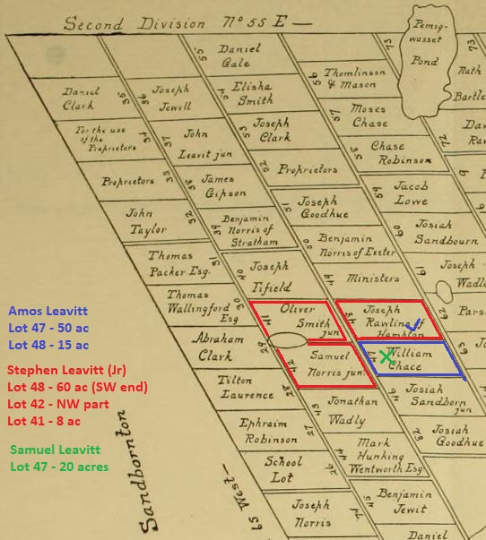 |
NALF NotesUpdates about our Leavitt genealogy research, our DNA projects, and other notes to keep our membership informed. Archives
September 2023
Categories
All
|

 RSS Feed